
We respectfully acknowledge that we live and recreate on the unceded traditional territory of the K’ómoks people (Pentlatch, Ieeksun, Sahtloot and Sasitla), the traditional keepers of this land.
Partners

2026 Platinum Sponsors







UROC promotes and supports the local Mountain Bike Community in the Comox Valley.
Through trail advocacy, volunteerism, promotion of the sport and fundraising, we are able to encourage participation for all as well as maintain and build the local trail infrastructure.
Membership
Membership with UROC supports trail access and maintenance, and allows you to participate in all UROC activities from our race events and group rides to community programming.
2026 Members
0

Community Engagement



View Instagram post by unitedridersofcumberland
Oct 22
Open post by unitedridersofcumberland with ID 18104508089637609


This year’s Gravity Nines saw 75 entries, with almost everyone completing the full route! Over half of all participants tackled all nine trails in a single day, and around 90% of entries were on acoustic bikes. That’s some serious riding!
🏆 And the winners are…
🥇 Gravity Nines Overall Winner: Avallee takes home a six-pack ski pass from Mount Washington Alpine Resort.
⚡ Nine-in-One Challenge Winner: kcinjordan takes home a six-pack ski pass from Mount Washington Alpine Resort AND a set of Race Face Turbine 30 wheels!
🔋 E-Bike Division Winner: Pasc81 wins a pair of Kona Wah Wah 2 pedals, sponsored by Comox Bike Co.
A huge thank you to everyone who entered and took on the Gravity Nines challenge this year. We hope the trails delivered a suitably challenging experience!
And to our sponsors, Mount Washington Alpine Resort, Race Face and Comox Bike Co., thanks for supporting the event and helping make it happen. 🙌
Next year, we might just step things up a notch and throw some upper Epic trails into the mix… 👀
Until then, keep riding, keep challenging yourselves, and remember: you’ve got to be in it to win it! 🚵♀️🔥
@mountwashington
@raceface
@comoxbikeco
View Instagram post by unitedridersofcumberland
Oct 21
Open post by unitedridersofcumberland with ID 18454649359193468

Chunder drop in all its glory.
FYI - Conditions are prime.
All G9’s prizes sponsored by:
@mountwashington
@raceface
@comoxbikecompany
View Instagram post by unitedridersofcumberland
Oct 16
Open post by unitedridersofcumberland with ID 18026512553859931

For every can or pint sold, $1 goes directly to UROC to support our local trail network.
Huge thanks Ace Brewing for supporting to Sarah Kempner for the photo, to Roam Media for the label design and to Shorewolf Farms for all those fresh fresh hops!
The Green Room will be available on tap and in cans, at Ace Brewing and select liquor stores across the Island - perfect for that well-earned post-ride pint.
Raise a glass to the trails, and the awesome community of trail builders that make it all happen!
@acebrewingcompany
@shorewolffarm
@sarakempner
@roammediainc
Recent Updates
-

WIN a 2026 Forbidden Reya Tier 3
Tier3 Model valued at $7600. Reya is a short travel trail bike ready to rip the legs off your lunch lap crew, reclaim your window of spiritual solitude while you sync with the trail, or be the little voice that says yes to those absurd backcountry missions.
-

Forestry operations commencing
Mosaic Forest Management wishes to advise users of the area shown in the below map (area marked in orange), that road reconstruction (labelled TRM10C & known as Above and Beyond trail) will commence in February 2026 with harvesting to follow. For the public’s safety, we ask that you avoid this area while active operations are…
-
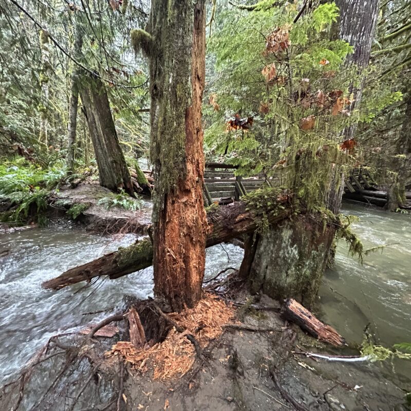
Perseverance Creek storm damage / trail closures
Extreme water flow has caused major erosion around the Perseverance Creek wooden bridge near the end of Hai Gai, DCDH, and throughout the China Creek trail floodplain area. A large log jam washed against the wooden bridge and is forcing volumes of water in multiple directions, washing out significant sections of trail and making the…
-

Joining the UROC Board of Directors
United Riders of Cumberland (UROC) is a not-for-profit society governed by a volunteer Board of Directors. The Board consists of 9 directors, each elected to a two-year term. Each year elections are held at the AGM, where every eligible member can vote for the Board of Directors. This year UROC is seeking to fill two…
-

Ten Years of Trust
How a Landmark Land Use Agreement Transformed Cumberland’s Mountain Bike Community By Mike Berard In December 2025, the United Riders of Cumberland (UROC) and the private landowners surrounding the village of Cumberland, B.C., Mosaic Forest Management, TimberWest, and Hancock now Manulife Investment Management, mark the ten-year anniversary of a land use agreement that reshaped the…
Become a
UROC Member
Membership allows you to participate in all UROC activities from our race events and group rides to community programming.
We always appreciate your support!
As we are a non-profit society, all Trail Boost donations go directly to building and maintaining the Cumberland Forest trail network.
Wildfire Information